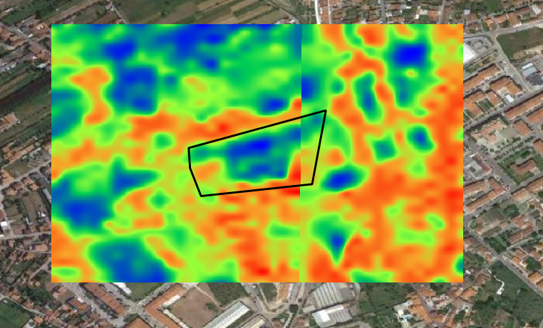
Hi, I’m trying to use the python module to acquire the S-2 NDMI for a specific area, but when I save them to my local drive they have some sort of glitch, like it was a result of merging two images. I checked the EO Browser and they seem fine. It only happens using the Python module. Image is attached.
Could you say a bit more about how did you construct this image? (a code snippet would be appreciated).
Here is the request:
wms_NDMI_request = WmsRequest(
data_folder=save_dir,
data_collection=collection,
layer=‘MOISTURE-INDEX’,
bbox=box.buffer(buffer),
maxcc=0.05,
# geometry=Geometry(geometry=geo, crs=CRS.WGS84),
width=512,
time=(start_date, end_date),
image_format=MimeType.TIFF,
config=config
)
That request in principle should not result in such a discontinuity, but it also depends on configuration of your ‘MOISTURE-INDEX’ layer, as well as on the start_date
/end_date
properties.
If you send me parameters, (including your instance_id, using DM functionality), I can have a look.
Just to add that this kind of a result is typically a consequence of either:
- stiching the data from different observations (e.g. if FROM/TO date are not the same)
- using Sentinel-2 L2A, where the atmospheric corrections, being run on the scene level, is sometimes a bit diffenent on neigbouring tiles (something that ESA is planning to address in the reprocessing campaign).
Reply
Login to the community
No account yet? Create an account
Login with SSO
Login with Saml2 Login with OpenIdConnectEnter your E-mail address. We'll send you an e-mail with instructions to reset your password.